Asking Price $4,600,000
5 2 2
A Rare Opportunity. 45 Years in the Making.
58 Mountain View Road, Dalefield
Ray White Arrowtown
Queenstown · Queenstown-Lakes District
Negotiation
This listing sells Lot 1, a new lot being created on this site. Its title has not been issued yet, so the council record, land and estimates on this page are for the site as it stands today. Subdivision consent RM250136.
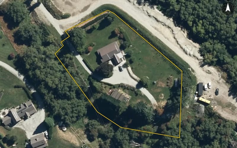
Occupying a prized position in Dalefield, this substantial 7,072sqm (more or less) landholding presents an exceptional opportunity to create a considered residence within one of Queenstown's most sought after rural residential locations. From it's unique sheltered position it captures an expansive alpine outlook, the 750sqm consented building platform takes in The Remarkables to the south, Coronet Peak to the north and Cardrona to the east, capturing natural light and sunshine throughout the day.
The setting combines generous scale with privacy, where established trees new landscaping complement the surrounding rural landscape. This level site offers services to the boundary, with a 5,000-litre daily water allocation, the property provides an excellent foundation for a residence tailored to its setting. Enjoying a peaceful semi-rural environment just 10 minutes from Arrowtown, Queenstown and Frankton, this is a compelling opportunity to secure a substantial landholding in a highly regarded location.
Preliminary concept plans for a premium home by Young Architects are also available.
Create a home that reflects the setting and makes the most of its remarkable alpine outlook. Contact us for further information.
Added to OwnBetter 18 Nov 2026
We estimate it would sell for $5,360,000 as at 5 October 2026, in a range of $4,400,000 to $6,530,000.
| Council valuation, Sept 2024 | $4,910,000 |
|---|---|
| Market movement in Queenstown-Lakes District since the council valuation | +6.4% |
| How Dalefield sells against council values | +1.0% |
| Homes of this age in Dalefield | +0.1% |
| Land as a share of the value | +1.3% |
| Nearby recent sales (7) | +0.1% |
| Our estimate | $5,360,000 |
We start from the council's rating valuation, move it by how sales in the area have moved since against their own council values, then by how properties like this one, nearby sales have done against the same arithmetic. Each step is an average of real sales. Tested every month against sales we had not seen: half land within about 6% of our estimate, and about 8 in 10 within the range. This is an automated estimate, not a registered valuation.
Sign in to rate this property, keep private notes on it and record what you think it is worth. Only you see them.
Estimates from the floor area and typical New Zealand prices, not quotes. Power, gas and internet details from the Electricity Authority and Gas Industry Co registries and Chorus.
From the council’s rating records and the other sources noted on hover. Bedrooms and bathrooms may come from a past listing. Built is the decade the valuer records.
Owner names and the parties to each instrument are not published on this page. Order the record of title to see them.
Another agency selling this property too, or is it for rent? Import that listing and it shows beside this one.
We hold no building consents for this property yet. The council may hold records we have not seen.
If it is yours, claiming it puts the council record, the title and what it costs you to hold in one place — and lets you put your lending, insurance and power out to people who compete for them.
We check your name against the registered owner on the title before a claim is accepted. Nothing on this page changes for anyone else, and no provider is contacted until you ask.
What the council's published maps say about this land. A map is a model of a storm, not a record of one: a LIM or a flood report says more.
Reading the council's maps…
See whether a granny flat fits beside the house: the Building Act exemption, the national granny flat rules and the zone’s own. Then ask builders to price the shape you pick.
Counts describe the records we hold for this territorial authority, not a market forecast. Our estimate above is automated, not a registered valuation; how it was reached is shown with it. Every council figure on this page can be checked against the council's own record.


The OwnBetter estimate is our own, from sales and council valuations, and is not a registered valuation.
A single search across NZ property records finds other titles in your name and in companies you are a director of. Most owners find at least one they had forgotten was held somewhere else.